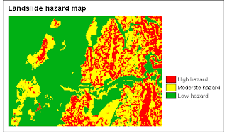
This is a method to make a hazard map based on quantitatively defined weight-values. Many different methods exist for the calculation of weight-values. The method used here is called the landslide index method.
Input Data
The landslide hazard map is made using only 4 parameter maps: Lithological map, Slope map, Slides Map and Mapping Unit.
Calculating landslide density for each parameter class
First, we make an attribute map of the landslides: by separate the fosil landslide and the recent one, we obtain a map which Active landslides (Br: Body of recent landslides and Sr: Scrap of recent landslide).
Then we use the Cross operation twice:
• to cross the landslide map with the existing Slope map.
• to cross the landslide map with the existing Lithology map
The Cross operation shows all occurring combinations of the input maps; the results are stored in a cross table. Next, we use TabCalc statements in order to calculate density values for active landslides:
• landslide density for the entire map, (AreaMapAct/AreaMapTot)
• landslide densities per Slope class, (AreaSlopeAct/AreaSlopeTot)
• landslide densities per Lithologycal unit. (AreaLitAct/AreaLitTot)
Creating the weight maps
After some steps in joining the calculated columns into a new table (to reduce redundant information), TabCalc is used to calculate weight factors for each slope class: ln(density of active landslides per class / density of active landslides in entire map) where LN is the natural logarithm. Next we calculate weight factors for the densities of active landslide per Lithological class. Then, we create two attribute maps, using the two calculated Weight columns. The first map thus contains weight factors regarding slide densities for slope classes; the second map contains weight factors regarding slide densities for Lithological units.
Creating the hazard maps
the landslide hazard map can be calculated using MapCalc to simply sum both weight maps.With Slicing, we classify the resulting hazard map into three classes of low, moderate and high hazard.
Landslide Loss Estimation

We calculate the number of building located in High, Moderate and Low Hazard. (Cros operation between Hazard and Mapping unit)
The Result:
1. Buildings in High Hazard
2. Buildings in Moderate Hazard
3. Buildings in Low Hazard

No comments:
Post a Comment